Conquering Indonesia’s Seven Summits: A Thrilling Adventure Across Volcanic Peaks and Remote Islands
Comprising some 17,000 tropical islands along the Ring of Fire, Indonesia offers volcanic eruptions, earthquakes, tsunamis, and the world’s highest rate of fatal crocodile attacks. With such thrills available at home, in 2008 Indonesian mountaineer Hendri Agustin created a domestic version of the Seven Summits, incorporating the highest peak – or ‘gunung’ - on each of Indonesia’s five biggest islands (New Guinea, Kalimantan, Sumatra, Sulawesi, and Java) and two largest archipelagos (the Moluccas and Lesser Sundas). And while, like all lists, it’s debatable, his selection was cemented by a book, website, and Hall of Fame. Starting with Dody Johan Jaya in 2011, several hundred climbers have completed the project.
Besides seeming a good way to sample Indonesia’s charms, I’d been unreliably informed that no Westerner-or - or ‘bule’ - had yet completed it, not that I’m egotistical. Coincidentally, I’d already climbed four of them - the Carstensz Pyramid (New Guinea), Kerinci (Sumatra), Semeru (Java), and Rinjani (the Lesser Sundas) – while ticking other lists. The remaining three weren’t technically difficult, but the logistics looked daunting. So, I contacted my local factotum, Aris Yanto. Since our first climb together 13 years earlier, his unruly black locks had thinned and greyed, but he’d retained that glint in his eye and quintessential manic giggle. We were joined by Mandy Ramsden, who has a fetish for any list involving seven.
Our first destination was the isle of Seram in the Moluccan archipelago. In fact, Seram is the Mother Island, at least according to Moluccans, who believe all life emanated from Mount Nunusaku, which is somewhere in the middle of it, but invisible to humans. Thankfully, our target was Mount Binaiya, although this wasn’t much easier to reach.
After several cancelled flights and rescheduled ferries, we arrived in Masohi, the main town on Seram. Before progressing further, however, we had to navigate a bureaucratic labyrinth. Thanks to Binaiya being the former base of the Moluccan liberation army and now within a heavily poached national park, we required permits from the park manager, police chief, and, less obviously, a local doctor.
Seram’s populace is evenly divided between Muslims and Christians, which is all very well, except we’d turned up on Good Friday during Ramadan, to find both creeds on holiday. Our predicament was confirmed by Aris giggling. We had to beg a nurse in A&E at the general hospital to perform our medicals, await the police chief to emerge from the mosque, then track down the heavily pregnant park manager at home. When, after a frantic few hours, we were cleared to go, even Aris looked surprised.
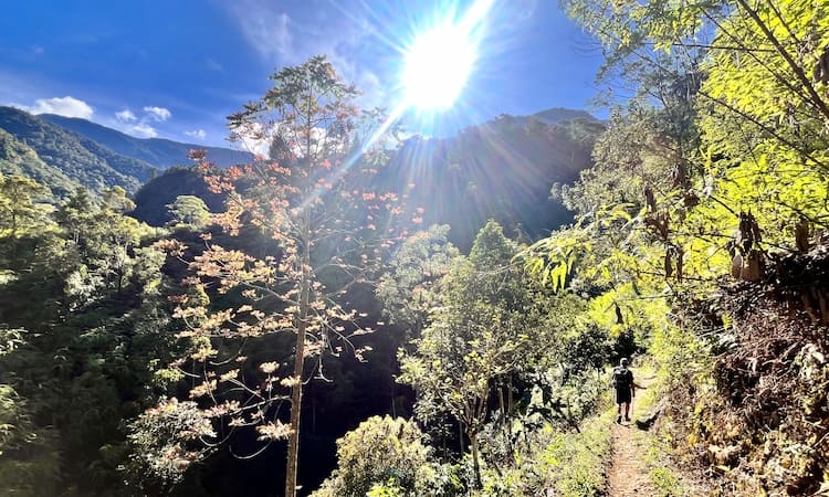
It was a three-hour car ride along the south coast to Piliana, which should have taken much longer but for our chauffeur being in getaway-driver mode. We cajoled him to pause for our first sighting of Binaiya, a multi-humped, karst ridge, topping 3000m. When I asked Aris which particular hump was the summit, he mumbled vaguely, which should have forewarned me.
A small farming village at 400m, Piliana’s landmarks were a large, half-built, half-collapsed church, and a much better-attended dirt volleyball pitch. Our final requisite permit was from the King of Piliana himself, to whom we were presented in his official palace, an unpretentious, dingy shack. A diminutive octogenarian with thin bandy legs, his Highness was regaled in a shiny red shirt, baggy red shorts, and pointy red headdress, and looked like a bottle of ketchup - though I was admittedly more respectful in his presence. The details of our audience got lost in translation, but he apparently granted royal approval for our climb, despite thinking I was German. We spent that night chez the prince, in what was hardly Kensington Palace, but we were offered the only bed.
Early the next morning, we set off on foot, accompanied by two local porters. One went barefoot and responded to ‘Jacky’; the other wore wellies and might have been Barry. After all the bureaucratic hurdles, I was hoping the hard yards were done and we could enjoy a pleasant amble, but we rather encountered a steep, slippery, switchback trail, consumed by vegetation and landslides. It took eight hours to cover 12km to our planned camp at 2145m, known as Pos 4. Most Indonesian trails have several designated campsites or Pos’s, which are typically small, flattish clearings, occasionally with running water, but always with abundant litter. Pos 4 was more salubrious than most, boasting a couple of wooden huts in varying stages of decay.
We left for the summit the following dawn, accompanied by Jackie, who seemed oblivious to the razor-sharp karst and local superstition forbidding villagers from going to the sacred top. Hiking up through vegetation, we emerged on a rolling ridge and, after four hours, reached the official summit marker at 3027m. Unfortunately, however, the true top was still 3km further on.
With no path to follow, the remainder of the ridge was a succession of taunting false summits, interspersed with densely vegetated ravines. It was like battling the Hydra,and we’d no sooner dealt with one head than another popped up. Several times I weakened and asked Aris if the next peak was the top, but each time he mumbled ‘Beyond’ and giggled - till we finally did reach a hump beyond which it only went down. It had taken another three hours to get here, for an extra seven metres in height.
We’d barely turned for home when there was a clap of thunder, the heavens opened, and I silently wondered whether Jacky’s sacrilegious presence was to blame. On the way up, displaying a spectrum of technological skills, Aris and Mandy had waymarked our route on their smartphones. I’d built stone cairns, and Jacky had hacked markings on trees with his machete. On the way down, in drenching rain and dense cloud, we needed all these navigational aids. When we squelched into Pos 4, just before nightfall, we’d been out nearly 12 hours. And when we stumbled back into Piliana the following afternoon, the royal household looked surprised to see us at all.
Our next port of call was Sulawesi, Indonesia’s fourth-largest island, which resembles a letter K, albeit doodled when drunk. On disembarking in Makasser and picking up a phone signal, we were disconcerted to learn that the local tribe had barred access to the island’s high point, Mount Latimojong, but then Aris remembered their chief owed him a favour. On the drive there, we passed through the homeland of the Toraja who, after extended, exorbitant funerals, stow their deceased relatives in cliff-face tombs, before regularly retrieving them, dressing them up and taking them on family outings, advanced decomposition notwithstanding. When I mentioned this to my mother, she struck me from her will.
At 1400m, Karangan was a relatively prosperous village, thanks to arabica coffee farming, and, as in most places renowned for its coffee beans, we couldn’t get a decent cup. More importantly, however, once Aris had paid a few visits, our climb was back on. With most local men too busy farming, the chief press-ganged two fashionably coiffed teenagers to be our porters. Grudgingly dismounting their motorcycles and shouldering loads, they trudged into our high camp three hours behind us, though they got the last laugh, since they were carrying our tent and it was bucketing down by the time they arrived.
Compared to Binaiya, Mount Latimojong was a refreshingly direct climb, albeit via some frayed washing lines up greasy rock bands. Early on the second morning, we tagged the summit, which was also called Rantemario and somewhere between 3443m and 3478m. Then, with clouds brewing, we raced down to Karangan, just beating the rain. To add to our sense of good timing, we’d no sooner left Sulawesi than a volcano erupted, triggering tsunami warnings and closing the airport.
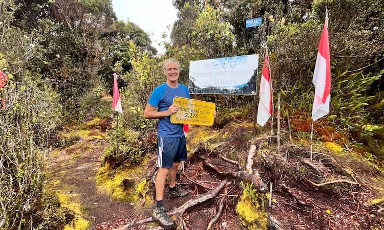
The last peak on my list was Bukit Raya, on Indonesia’s large chunk of Borneo, known as Kalimantan. At 2278m, it’s the smallest of the seven and not even Borneo’s high point, which is Mount Kinabalu, on the Malaysian side - but as any (small) man will tell you, there’s more to it than size.
With Kalimantan long on conflict, but short of infrastructure, our first challenge was getting anywhere within the peak’s vicinity. Bukit Raya lies in the Müller-Schwaner Range, which I’d also never heard of, but some research might have deterred me. Georg Müller was a German soldier who in 1826 attempted to traverse across Borneo, to be decapitated en route; while Carl Schwaner was a German geologist who in 1847 trekked from the southern tip to Pontianak on the west coast and died of fever.
From Jakarta, we flew to Pontianak, which got the easy part done. We then faced an overnight bus ride to Nanga Pinoh, which I spent folded in half. Indonesian men are amongst the world’s shortest; an irrelevant fact unless you’re an average-sized bule travelling long distances on public transport seemingly designed for midgets. I felt I’d been incarcerated in one of those medieval torture cells that are too small to stand up or lie flat in. That Indonesian men are World Smoking Champions is also irrelevant, unless you’re confined in close proximity.
The main arterial highways through Kalimantan’s interior are its rivers. So, after a brief spine stretch in Nanga Pinoh, we chartered a flimsy motorboat to take us up the Melawi River, which might sound exotic, but was an environmentalist’s hellscape. The banks were lined with barges dredging for gold, spewing back mud; the riverside settlements dumped rubbish and sewerage straight into the slurry; and the only architectural features of note were tall, corrugated-iron towers built to lure swallows and pilfer their nests.
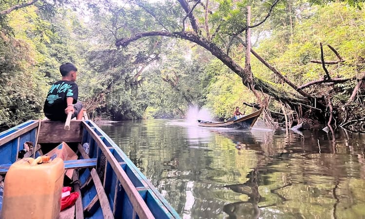
After four hours, we reached the confluence with the Serawai River, where we downgraded into a ‘klotok’ – a traditional open wooden longboat with a wheezy outboard engine. Though we faced another uncomfortable four-hour voyage, thankfully, this river was cleaner, since several times we had to leap out and catch the underpowered klotok as it baulked at rapids and threatened to flip.
The last village upriver, Rantau Malam, was home to a Danum clan, part of the Dayak tribe indigenous to Borneo’s interior and, until recently, partial to headhunting. The villagers used to share one long wooden house, built on stilts three metres off the ground, though we were accommodated in a more accessible homestay. Some of the young Danum men showed us their rifles, machetes, and homebrew, which we politely declined, thinking it best if everyone stayed sober.
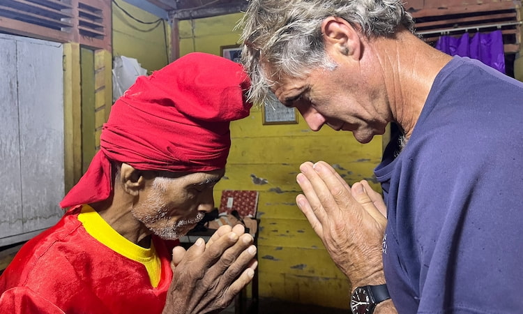
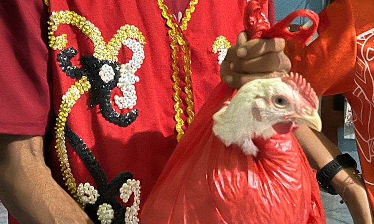
With Bukit Raya sacred to the Danum, we required a blessing from the local shaman. Who turned up that evening in a practically coloured red waistcoat, bearing a machete and a rightly alarmed white chicken. After daubing us with its blood, the shaman presented us with wrist bracelets which he instructed must be worn at all times, pressing his machete to our foreheads for good measure. The chicken reappeared after the ceremony as ayam sambal.
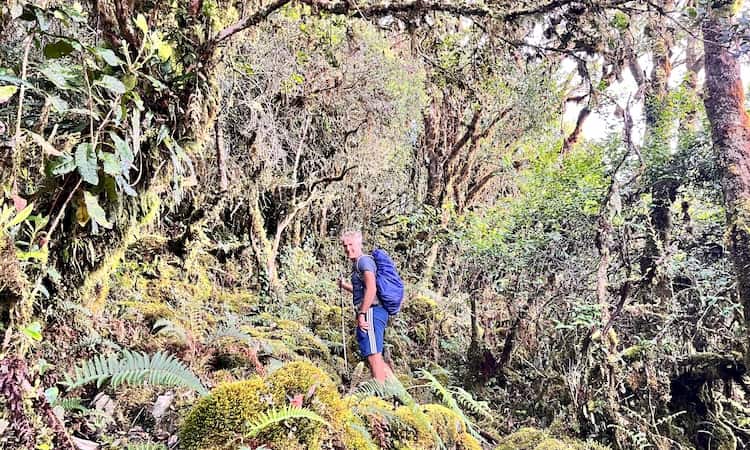
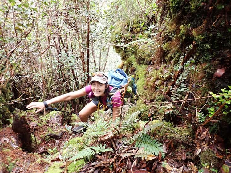
The next morning, we left on foot with three Dayak porters bearing loads in homemade rattan backpacks, which looked as comfortable as wearing planks. After a thigh-deep river crossing, we entered the jungle, just as it started raining. ‘Oh no, now leeches wake up,’ giggled Aris.
Each jungle I’ve been in has had its own special torment: mosquitoes in the Amazon, snakes in Belize, and here it was,s leeches. Half a finger’s length in size, they sensed our coming and looped relentlessly towards us, swarming our boots. When we stopped to prise them off, more leapt aboard. Soon, my socks squelched with blood, and my legs looked like they were haemorrhaging. By the time we reached Pos 5 at 720m, after 20km, I’d almost bled out.
With night falling, we hastily threw up our tents and dived inside. But despite strict security measures, the leeches snuck in too and invaded our sleeping bags. It was like discovering zombies inside your saferoom, and I could feel my newly acquired bdellophobia welling. That night, sweaty and nauseous, I fumbled with my headlamp to discover the shaman’s lucky bracelet had fallen off my wrist – and when I tied it back on, the nausea left. Explain that to me, if you can. Not that it got rid of the leeches.
Departing at dawn for the summit, we faced 13km of stout jungle trekking, up muddy flanks, over fallen trees, sometimes crawling, while garrotted by rattan vines and preyed on by leeches. There were signs every 100m marking the route and counting us in, which was dispiriting given we were averaging 1½ km per hour.
It was mid-afternoon when we finally stumbled into a small clearing festooned with summit boards. Though I still faced several blood-sodden, spine-crunching days to get home, I now belonged in the Hall of Fame - if not in the same alcove as Muhammad Abdullah, the only climber so far to have used a bicycle as his main mode of transport.
Helpful Tips: Aris Yanto of Ndeso Adventure guides all seven summits and can shoulder the many logistical stresses for you (www.exploredesa.com). There is information on each of the peaks on Hendri Agustin's website www.the7summitsindonesia.com