Climbing Pico Simon Bolivar: Columbia's Highest Mountain
‘Ten miles to the top, with 4000 feet of ascent,’ pronounced John, as we huddled in the mess tent. ‘Tomorrow will be a long day,’ he added ominously, before toppling backwards off his campstool, kicking over the table and tipping a bowl of tuna pasta into my lap.
This was my third trip to Colombia, the home of magical realism, where the unexpected generally happens. On my first visit, in 1990 as a banker, my Bogotá presentation was interrupted when the windows imploded. Though bombings were mundane and my audience was unfazed, I fled to the airport and fortuitously caught an earlier flight home, since my scheduled plane ran out of fuel circling JFK and crashed, killing 73 of the 158 passengers. On my next trip, climbing Colombia’s fifth-highest peak, we got down to find our high camp had been stolen. And since then, attempts to organise an expedition to Colombia’s highest mountain had been thwarted by hostile natives, who inadvertently spared me from climbing the wrong one.
There’s always been some debate as to Colombia’s high point, with two adjacent peaks in the Sierra Nevada de Santa Marta vying for this title. Having spotted these snow-capped spires from a cruise ship, American business magnate and CIA operative Tom Cabot discovered they were unmapped and unclimbed, and assembled an expedition to remedy this. On arriving in Santa Marta in March 1939, he found he’d been gazumped by a trio of European expats - Erwin Kraus, Gustav Pichler and Enrico Praolini - who’d just bagged the massif’s central peak, which was christened Simón Bolívar (after ‘the Liberator’ who freed Colombia from Spanish rule).
Slightly consoled by Praolini’s comment that its neighbour looked similar in height, Cabot recruited him to his team. A fortnight later, Praolini, Walter Wood and Anderson Bakewell climbed Pico Cristóbal Colón (after the 15th-century navigator, aka Christopher Columbus, who facilitated Spain’s colonisation of Colombia). Though the Americans conceded their triangulation measurements showed Bolívar to be two metres taller, they mapped both peaks at 5775m, arguing the heights would vary with snowfall. And over time, Colón surreptitiously became the national high point, possibly because it was easier to climb. By the late 1980s it was a moot point, as drug cartels, left-wing terrorists and right-wing paramilitaries invaded the foothills, terminating sensible access.
Fiona and I arrived in Santa Marta early to shake off jet lag, to be kept awake by constant street music and firecrackers. The residents of Colombia’s oldest colonial city seemed proud of its association with Bolívar (who died of TB here in 1830, while trying to leave) and Nobel Prize-winning author ‘Gabo’ Márquez (born 80km away), but mostly they liked to party. Eventually, we felt sufficiently attuned to meet our expedition leader, Colombian guide Ricardo Rubio Jiménez. Though large swathes of the Sierra Nevada were still no-go zones, Ricardo had forged a way to the peaks by patiently building trust with the indigenous Arhuaco tribe and making donations to paramilitaries.
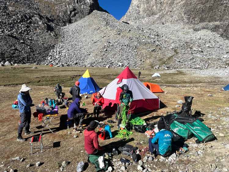
Our expedition assembled in Rodadero, a beach resort adjoining Santa Marta, where we squeezed our bags and selves into a convoy of station wagons. There was one other gringo on board, an Arizona surgeon named John Klein, who’d already nipped up two 5000m peaks that week, making me feel quite slothful. The other three clients - Mario, Dan and Juan, from Bogotá – were athletic, accomplished and acclimatised, and I hoped nobody proposed playing ‘The Weakest Link’. To chaperone us, we had five guides, including Ricardo, with Fiona and me allotted to David Silva, a Colombian living in Ecuador, who was thankfully fluent in English, since Fiona’s Spanish lessons were proving a poor investment. And to feed us, we had a flute-playing, vegan cook, Alejandro and his stoic assistant, Sebastian. The Colombians on our team were a palette of browns – with the population blended from indigenous natives, European adventurers and African slaves - and unfailingly generous and kind, which was difficult to square with their country’s history of grotesque, random violence.
On the drive to the trailhead, we marvelled at how farmers grew avocados on such steep ground, only to learn it was often dictated by the mafia, who found the fruit handy for smuggling cocaine. And over lunch at San Pedro, an innocuous trading post with a cheerful ‘I Love’ sculpture, we were told the hamlet was governed by paramilitaries.
Above here, the road deteriorated into muddy hairpins before expiring at the Arhuaco village of Yerbabuena, at 2100m. Comprising a few scattered huts, the settlement was architecturally inferior to the recently found Lost City of Teyuna, with its 1200 stone steps, paved roads, irrigation canals and concentric carved terraces, constructed by the Arhuaco’s ancestors, the Tairona, back in the ninth century – but then so was Santa Marta.
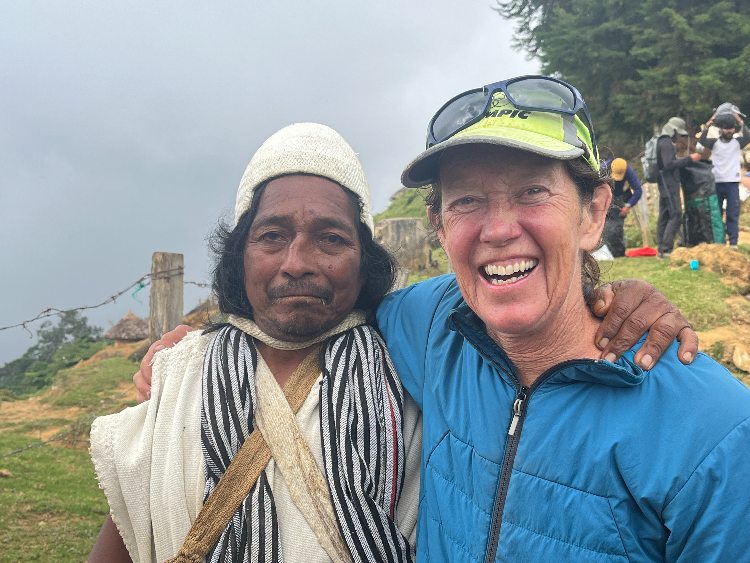
We were greeted by the village ‘mamo’ or chief, who sported a long white smock, baggy pants, crocheted hat and woven manbag filled with coca leaves, and wanted half-a-dozen pesos for his photo. As we set up camp in a sloping meadow, village children played hide-and-seek in our tents, and village dogs jostled for prime spots around Alejandro’s kitchen. Most Arhuaco adults kept their distance, however, seeming taciturn, verging on rude. To be fair, they had every right to be wary of outsiders, given the Tairona had been butchered by the Spanish conquistadors.
On our first night under canvas, we got little sleep, thanks to a cacophony of dogs, monkeys and cockerels that started crowing well before dawn. Once the sun did arrive, we packed our gear onto mules and squelched up muddy runnels hemmed by giant ferns, till we broke out of the cloud forest. It was an exotic but arduous first day, and nearly dusk when we reached our next campsite, beside Sacred Lake at 3700m.
From Yerbabuena, it was 55km to our planned base camp. Some days we made over 15km, and others just five, but every day was demanding, with sizeable ups and downs, across challenging terrain. Beyond Sacred Lake, our bags were carried by 19 Arhuaco porters led by Salomón, the mamo’s eldest son. Occasionally, we followed a faint path or sporadic cairns, while Salomón led the more convoluted sections. Initially, I thought he was consulting a GPS, but he was actually stirring his ‘poporo’, a hollowed-out gourd containing crushed seashell paste, which, when applied to coca leaves, enhances their buzz.
Crossing a high pass on the second day, we got our first view of Colón and Bolívar, along with Simonds, Colombia’s third-highest peak. Sharp, angular and clustered together, they resembled the Giza Pyramids. And shortly after that, we met a Czech team and their porters traipsing out, having backed off Colón in waist-deep snow.
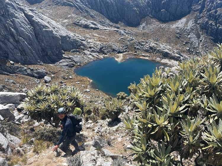
Above the cloud forest, we entered the Páramo, a tropical, high-altitude ecosystem, replete with orchids, lupins and groves of frailejones, some over two metres tall and centuries old. ‘Try not to harm these beautiful ancient trees,’ groaned David, as I bent one in half, using it to self-arrest.
We came upon waterfalls, rivers and lakes sacred to the Arhuaco, who believe the Sierra Nevada, which they call Chundua, is the heart of the world. In their cosmic view, they’re our Elder Brothers, and we’re feckless wastrels, and on this, they might be right. We usually camped on pristine lakeshores, which won’t be for long if many more expeditions stomp through, with no proper ablutions.
As cosmic guardians, our Elder Brothers were admirable, but as porters weren’t so stellar. Each day, they typically dribbled into camp several hours after us, minus a few who’d got lost enroute, prompting our guides to go fetch them and their loads. Meanwhile, according to Arhuaco custom, men don’t cook or wash up, requiring Alejandro and Sebastian to cater for all 19 of them too. But having said that, they’d allowed us through their sacred land and carried our bags, failing which we’d have had no trip.
On our fifth day, slogging up to another sacred lake, we passed a broad, green river valley, dotted with a few rondavels and cows. These were summer grazing pastures of the Kogi tribe, who are also descended from the Tairona, wear white smocks, believe Chundua is the planet’s heart, think they’re the Elder Brothers, and chew on the divine leaves of immortality. While coming through their lands would have provided far quicker access to the peaks, the Kogi are less welcoming than the Arhuaco and even less reliable as porters. We didn’t meet any Kogi, but we did bump into a Colombian trio hiking out, who encouragingly had summited Colón.
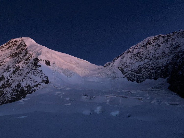
The following day, after traversing beneath Simonds Peak, we reached Colón base camp, in a large grassy meadow at 4550m. As the only residents, we spread ourselves out. Indeed, with a creek running through, it seemed an ideal spot, till the sun disappeared before three pm, casting us into frigid shadow. There was also the disconcerting spectre of Colón and Bolívar towering above.
The next morning, after enjoying our first lie-in, I briefly bathed in the numbing stream. I’d long abandoned shaving. Whereas Arhuaco don’t sprout facial hair, the Colombians looked like dashing Che Guevaras, and John had a battery-powered razor, I resembled a seedy shopping mall Santa. Otherwise, it was a lovely morning, with condors circling overhead and just the occasional drone of a plane reminding us that the coastal highway was only 50km away - though reaching it would be a different matter. Meanwhile, some Arhuaco ventured down the valley to return with the severed hindlegs of a cow, which they presented to Alejandro to cook.
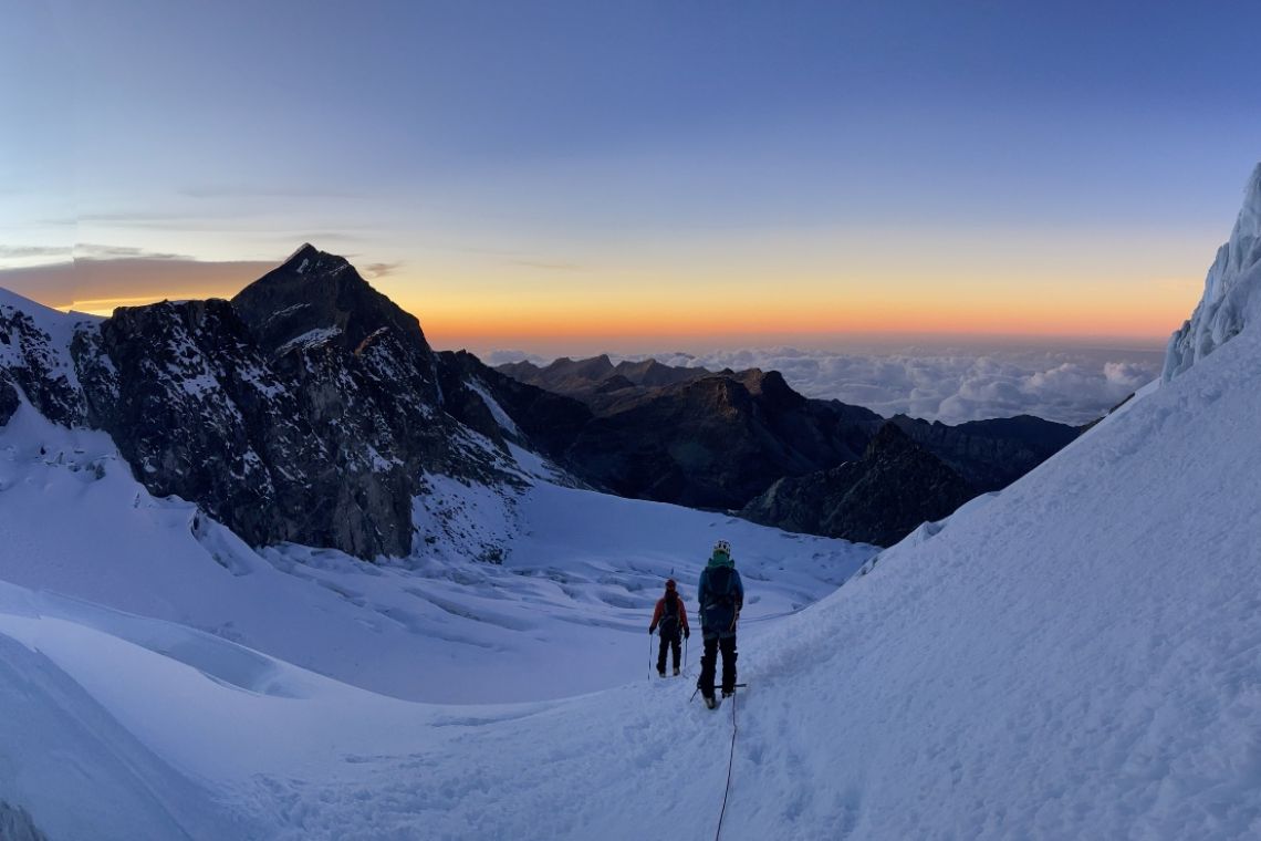
We left camp on our summit bid at 11 pm. As John had predicted, it would be a long day. The night sky pulsed with stars, while down the valley was an orange glow from the campfire of some Kogi herders, who were possibly searching for a missing cow. After two hours, we reached the snowline, where we strapped on crampons and tied into ropes - Fiona and I with David. Initially, the snow was hard and steep, and my lungs and calves burned. ‘It will flatten out soon,’ encouraged David, but it didn’t for several hours.
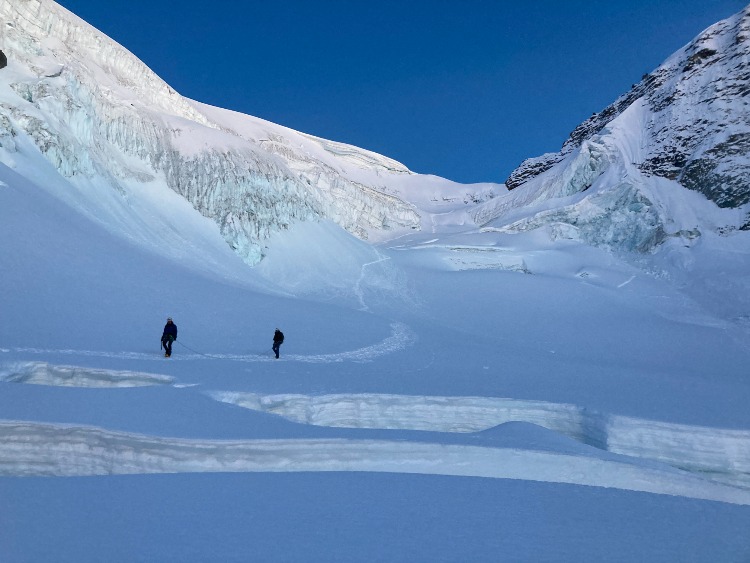
From the swivelling beams of our headlamps, it was difficult to gain perspective, but as the sky lightened, our environment was unveiled. For starters, it looked like we’d got a perfect summit window, with a clear blue sky and no wind, which was contrary to the forecast, and I was well over-dressed. Meanwhile, we were halfway up the glacier, zigzagging towards the col separating Colón on the left from Bolívar on the right. And, most pertinently, we were crossing a narrow snow bridge threading between deep crevasses. The Colombian trio who’d kicked in this trail hadn’t lacked cojones.
It was seven am when we reached the top of the glacier, where our plodding progress was obstructed by a headwall, some 30m high, 60 degrees steep, including a 10m pitch of shiny blue ice. It was for this that we’d brought technical ice-axes, and I wanted full value, wielding my pick as if auditioning for ‘Psycho’. My rampage was interrupted by David reminding me, as the last climber up, to retrieve the protection. It requires some dexterity to remove ice-screws, balanced on front points, without dropping your tools - and I just caught one on a boot, before it disappeared into the bergschrund below. The top section of the headwall was like porridge, and I almost drowned before bellyflopping over the lip.
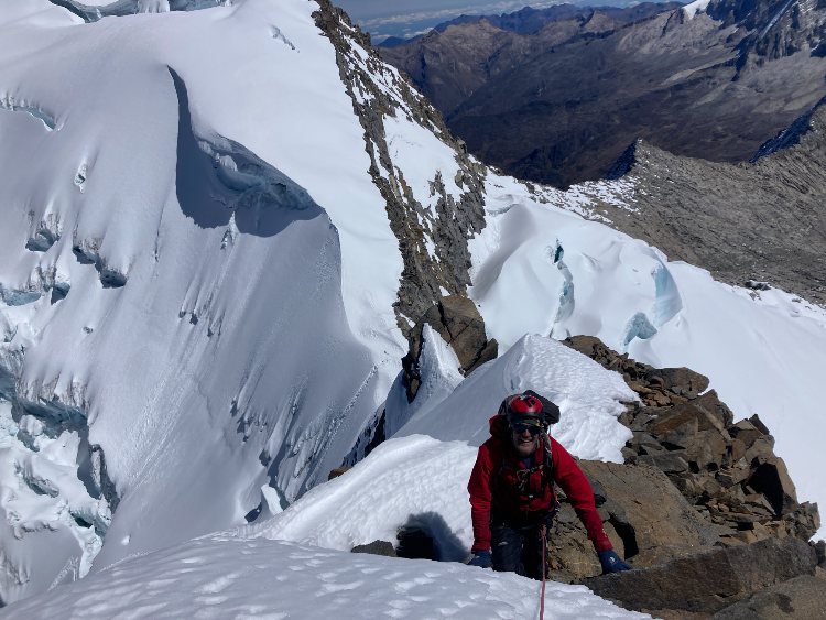
From the col, a trail of crampon prints indicated the Colombians had first headed up Colón, which was a one-hour stomp away. We headed right instead, focused on Pico Simón Bolívar. Though Colón had long been accepted as Colombia’s high point, in December 2024, Ricardo climbed both peaks and measured Bolívar to be 10m higher. A few days later, its top-dog status was fittingly endorsed by an American professional surveyor and country highpoint bagger Eric Gilbertson, who lugged his instruments up Bolívar and calculated it as seven metres taller than Colón, at 5720m.
Although we only had about 200m more elevation to gain, the going got tricky. The original route followed a snowfield up the north face, but this was riven with seracs and crevasses. So we rather took the one discovered by Ricardo the previous year, which he’d named ‘Aju’ or ‘Coca’, and was suitably stimulating. After descending 25m down a snow chute on the opposite side of the col, we traversed for over an hour along cluttered, rubbly ledges on Bolívar’s snow-free, south face, before clambering up a chossy gully, with plentiful but friable holds. Wriggling round a chockstone, I crawled onto a small platform, relieved that we were surely there. ‘You’ll want your crampons back on,’ advised John, who was waiting to start abseiling down. ‘Magnificent! You've made it!’ enthused Juan, having summited both peaks before I’d managed one. But his congratulations seemed premature, for we still had to negotiate an airy, snowcapped arête studded with boulder problems.
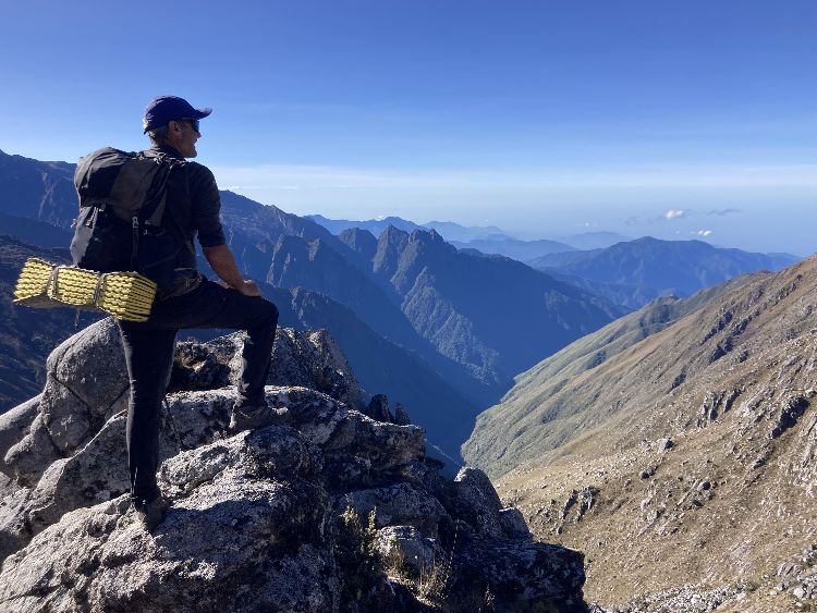
After 20 more minutes, bang on high noon, I gingerly tottered onto the narrow apex, which largely comprised an overhanging cornice. The panorama was dazzling, with shimmering glaciers, glinting peaks, turquoise lakes and, on the horizon, the hazy Caribbean Sea. Perhaps this was the world’s heart after all. But my gaze was rather focused on Pico Cristóbal Colon, half a kilometre across the col. When standing on tiptoe and squinting, it definitely looked lower.
We were joined on the summit by Ricardo and Mario, who’d come from Colón. ‘Did you measure it again?’ I asked Ricardo, affecting casual interest. ‘Bolívar is higher,’ he stated, which was good enough for me. And Pico Simón Bolívar certainly seemed a more fitting high point for this complicated, haphazard country. Ricardo thought they’d been less than 50 ascents of Bolívar in total, and that we might be the first Brits and Fiona the first woman – but this was by-the-by, for we still had to get down.
As we abseiled onto the glacier, the sun slipped from view. And by the time we got off it, night had definitively fallen. Trudging back in the dark, we repeatedly lost the trail and our humour, especially Fiona, when her headlamp failed, and she stepped into a lake. When we finally found base camp, we’d been out nearly 24 hours.
‘You look haggard,’ observed John the next morning, when I limped over for breakfast. There were still four tough days before a shower and shave in Santa Marta, but I was refreshed by the knowledge I’d climbed Colombia’s highest peak - unless somebody gets their tape measure out and asserts it’s Colón, which would be annoying if apt. After all, having driven the Spanish from Colombia, Bolívar was forced out too, penniless and reviled. His last words from his Santa Marta deathbed were ‘Fetch the luggage. They don’t want me here.’
Useful Contacts
Ricardo Jimenez of Ascenso Andino organises guided climbs in the Sierra Nevada de Santa Marta: www.ascensoandinocolombia.com;
Photos by: MATTHEW HOLT, FIONA McINTOSH and DAVID SILVA
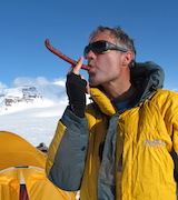
Matthew Holt
Matthew Holt has climbed the seven continental summits, skied to both Poles, and chanced his arm at bog snorkelling, cheese rolling, wife carrying and bull running amongst other misadventures.
Discuss this article
Clicking links may earn us commission. . Stock images by Depositphotos.
Subscribe: Stories about wildlife, habitats and heroes
Welcome to Conservation Mag where we celebrate nature preservation through ecotourism and wildlife travel while we look for ways to preserve our heritage by supporting nature conservation. Starting conversations about the positive action people like you and I are taking to make a change.
Quick Links
Work With Us
![]()