Flying north from Edinburgh, I was dazzled by cobalt sky and spangled Atlantic. Suddenly, our plane was swallowed by a black cloud, rain lashed the portholes, and we hit the ground hard. I thought we’d crashed, but apparently this was a standard landing at Sørvágur Airport.
My wife Fiona and I had come to the Land of Maybe, aka the Faroes, an archipelago of 18 isles midway between Scotland and Iceland, best known for its appearances on the BBC’s 'Shipping Forecast' when it's synonymous with gales. Though officially Danish, the islanders have their own language (descended from Old Norse) and currency (worthless elsewhere).
Deplaning by steps, we got soaked scurrying across the apron. By the time we were driving off in our rental car, however, we were squinting in the sunshine. With nowhere more than five kilometres from the sea, the weather changes fast here. Leaving the airport, we were confronted by severe basalt peaks and waterlogged moors. You wouldn’t want to get stranded outdoors here, which was disquieting for we planned to go hiking.
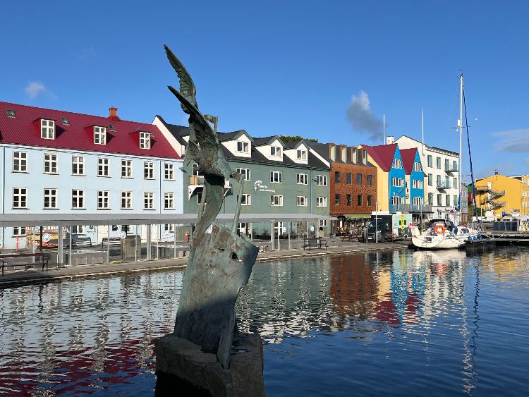
Seven of the isles are linked by tunnels and bridges; the remainder are less reliably linked by ferries and helicopters. A tunnel took us from Vágar to neighbouring Streymoy, towards the bright lights of Tórshavn, the capital city. We based ourselves here because we couldn’t find accommodation anywhere else, but it proved a smart choice. The capital boasted a plethora of top-notch eateries, whereas outside it, we rarely found an open shop.
The Faroes’ population is 55,000, of whom half live on Streymoy and one-quarter in Tørshavn. Meanwhile, seven isles have under 100 residents, one is home to a single family, and another’s been empty since the Vikings left. According to Norse sagas, the Faroes were settled by Viking tax exiles in the late ninth century. The sagas don’t mention what happened to the Celtic monks who’d arrived earlier, but it doesn’t require too much imagination.
Named after Thor, the Norse god of storms, the capital is also the Faroes’ major port. We’d rented an apartment close to the rocky promontory where the Vikings held their Thing or assembly, and now hosts its modern successor. Occupying a single-storey, red wooden building with a turfed roof, the Løgting was surprisingly accessible, and we inadvertently knocked on the PM’s door and peered into the Finance Minister’s office.
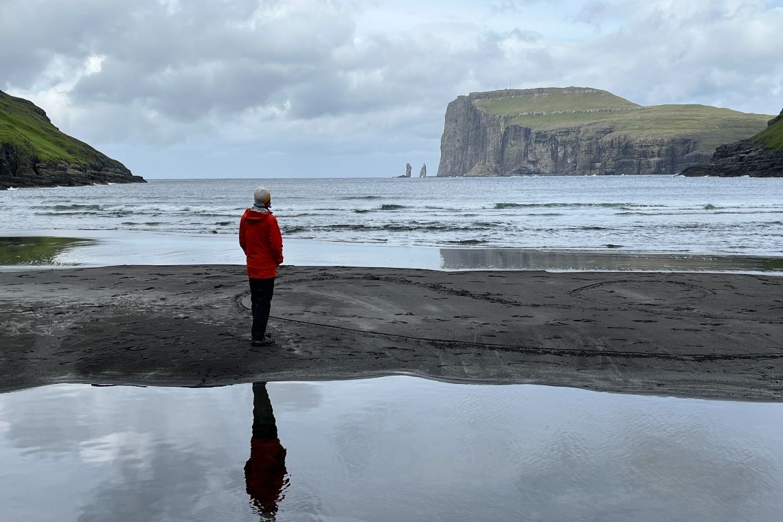
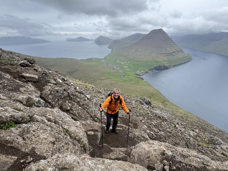
The first morning tested our resolve, and we risked hypothermia, dashing to the car. We’d come in June, the driest month, and it rained every day. With the Faroese language containing over 100 words for rain, this is Valhalla for pluviophiles. Our first goal was the islands’ 880m-highpoint, Slǣttaratindur, hoping it was easier to climb than enunciate. With the peak located on Eysturoy isle, we got to drive through the Faroes’ longest subsea tunnel. Some 11kms in length, it boasts the world’s first underwater roundabout, nicknamed ‘the Jellyfish’, where I almost caused a subsea pile-up repeatedly circling, while Fiona took photos.
According to our guidebook, the easiest way up Slǣttaratindur was from a col at 390m, where I parked, ignoring Fiona’s suggestions of finer lines. Seizing a weather window of misty drizzle, we headed up a well-trod track and, hopefully, the right peak. The path was probably never more than a steep walk, though in the swirling murk it became somewhat vague, and we found ourselves scrambling up rock bands onto the flat top. From here, on a good day, you can see all 18 isles, but we were pleased just to grope our way off. Fiona then wanted to climb the island’s second-highest peak, Gráfelli (856m), which is reputedly more challenging and somewhere nearby, but fortunately, we couldn’t find it.
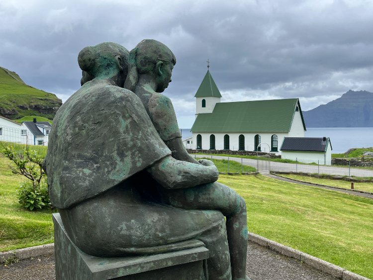
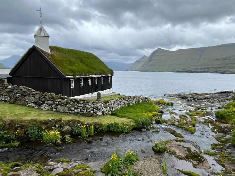
Instead, we popped into the fishing village of Gyógy. Slippery steps led down to the harbour, huddled in a gorge, where launching looked suicidal. The Faroes economy is predominantly fishing, but even the inland salmon farms looked like sets for ‘The Perfect Storm.’ By the church, a bronze mother and two children looked forlornly out to sea, while plaques commemorated the many drowned husbands and sons.
Driving back to Tórshavn, we spotted a long-finned pilot whale cruising close to the shore. While not endangered as a species, this particular one was, given it was whaling season, and this fjord was a productive ‘grind’ spot. The grindadráp (or ‘grind’) is a centuries-old community event where whale pods are driven up shallow sounds, where they’re sliced open and bled out, turning the bay a viscous red. The islanders have been meticulously recording their catches since 1584, with the annual tally now around 700. Dolphins and porpoises also go in the pot.
That evening, we splurged at Hotel Hafnia’s all-you-can-eat buffet, consuming several kilos of crab, prawn and langoustine. I spoiled my entire meal, however, by sampling the boiled whale meat and dried blubber. Perhaps it was my conscience causing indigestion, but the taste was also vile. I later discovered it wasn’t even good for me. Once considered a healthy source of protein and minerals, there are now concerns that whale meat is contaminated with mercury, causing Parkinson’s, hypertension, arteriosclerosis and infertility. Dolphin meat is even worse for you, but there wasn’t any on the buffet spread.
Renowned as the ‘tunnel kings of Europe’, the Faroese justify the construction expense on the grounds that they connect isolated communities, such as Gásadalur on Vágar’s northwest coast. When we popped out of the two-kilometre-long tunnel that was blasted through the obstructing mountain in 2003, there was a funeral taking place at the small white church. It looked like a pretty good turnout considering the village population had just been reduced to 10.
The tunnel had clearly transformed the village economy, and we sheltered from the rain in a cramped, tilting cottage selling homemade knitwear. The Faroes means ‘Sheep Islands’ in Old Norse and, until they got deep-sea fishing boats, their principal exports were woollen socks and baggy sweaters. The shopkeeper warned us off attempting the so-called Postman’s Route, which only strengthened Fiona’s intent.
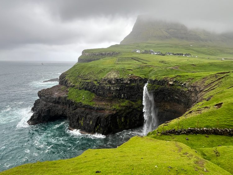
Before the tunnel opened, the local postman stomped over the mountain to deliver mail, with his 10km round now a signature hike. The trail started at Múlafossur waterfall, which was meant to be cascading off the cliffs into the sea, though most of it seemed to be blowing back into our faces. After zigzagging up a loose gully, the path tracked daringly along the cliffs, where we were occasionally blown off our feet by the thankfully onshore wind. A sign pointed out where pallbearers plonked coffins down for a breather - since before the village got its own cemetery in 1873, corpses also had to be lugged over the mountain. The descent on the other side was more gradual, allowing us to focus on batting off aerial attacks by agitated oystercatchers.
The comparative metropolis of Bøur had some 50 residents, many inhabiting turf-roofed, wooden houses. Outside the capital, most abodes stuck to this traditional design, and we didn’t see any ostentatious piles. We didn’t witness any homelessness either, but the climate probably solved that, while few migrant inflatables would survive the crossing. Should you fancy a quaint getaway in this egalitarian wilderness, however, only Danish nationals can purchase property. Having opted to return over, rather than through, the mountain, we bumped into a villager galloping along in just a t-shirt and shorts, who was possibly the former postman’s son.
We called in at the World War II museum, housed in a pockmarked, green building that was formerly the Command Centre. In April 1940, when the Nazis overran Denmark, British troops promptly seized the Faroes in ‘Operation Valentine’, to protect the North Atlantic shipping route. With over 8000 Tommies based here, military occupation brought dramatic change, including an airport, dance halls, Dairy Milk chocolates and Digestive biscuits.
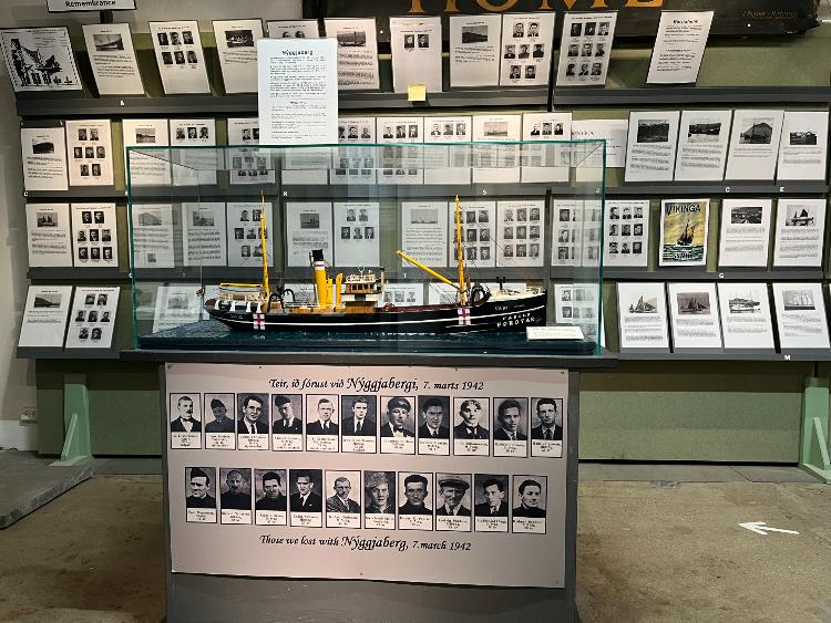
Though we’d pitched up outside opening hours, curator Jon Hansen kindly showed us around. The operation map was still on one wall, albeit missing the critical section showing the Faroes, which had been destroyed by the previous occupant, a car mechanic. In fact, other than a few air raids, there wasn’t much action here, and it was a cushy posting but for the climate. It was British soldiers who coined the islands’ nickname 'Maybe Land', because the bad weather changed most plans. Other exhibits included a couple of tandem motorbikes. ‘Mostly, it was a local girl on the back, grinned Jon, with Operation Valentine aptly named. The most poignant room contained photos of the sloops and over 200 crew lost to submarines and mines, as Faroese fishermen braved the Shetland Channel, supplying food-strapped Britain with cod and haddock. On the plus side, while the British ran military matters, the islanders got their own flag and domestic autonomy. When the war ended, they voted in a referendum for independence, but Denmark claimed the result was too tight and rather granted home rule.
Since you can’t come to the Faroes and remain a landlubber, on our third morning, we boarded a voyage out to the Vestmanna sea cliffs to view puffins (who are generally served boiled, with potatoes). There was a Gale Force Eight warning, obviously, but the Faroes aren’t for fair-weather tourists. When we left the sheltered bay, we felt the sea’s power. ‘It would be best to sit down and hold on,’ announced the skipper calmly, as the boat lurched and fell off a big roller. Passengers holding the portside rail were suspended in mid-air, while those sitting starboard dropped below sea-level. ‘Some days we must accept the sea makes other plans,’ conceded the skipper philosophically, wheeling the boat around and heading for safety.
Back on steady land, we staggered over to the Faer Isles Whisky Distillery. Despite it costing a fortune and tasting like moonshine, I was in the market, for we’d drained our duty-free booze and replenishing stocks wasn’t easy. Faroese women joined the electorate in 1906 and promptly voted to ban alcohol. Though prohibition ended in 1992, puritanical attitudes persist, with no drinking or dancing on church holidays, and alcohol only sold by a government-run store, during restricted hours. We were outside said hours, and the distillery wouldn’t slip me a dram.
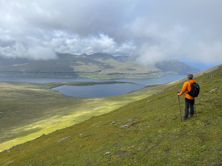
Apart from abstinence, Viking heritage runs deep here, with several sites providing an insight into the islanders’ formidable ancestors. We followed the six-kilometre trail above Leitisvatn inland lake to the 140m-high Trǣlanipa sea-cliffs, from where the Vikings tossed those slaves who’d become too infirm or elderly to pull their weight. And we paid our respects at the Viking cemetery just outside Tjørnuvík, on Streymoy’s northeast tip. It was a dramatic last post, looking out across a black sand beach at jagged sea-stacks, if not as dramatic as being cremated in your longship.
My favourite Faroese hike was on Viƌoy, from Viƌareƌi up Villingardalsfjall, the islands’ third highest peak. Though only three kilometres to the summit, there was a stout 800m of ascent involved. We set off in the late afternoon, unfazed about being benighted, with sunset not till 11.30 pm, and sunrise shortly thereafter. Our progress was halted by a wooden collection box and a notice requesting a payment of 200 Faroese Króna (US$ 32) each. While the construction of tunnels has connected previously remote spots, it’s also caused friction between ramblers and landowners, who want compensation for facilitating access. We came across several such honesty boxes at trailheads, but resisted the temptation.
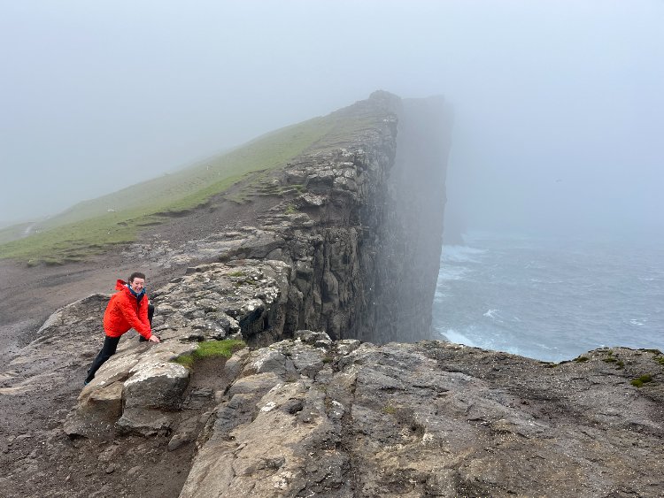
To give this farmer his due, as the path wound up rock bands, we were grateful for the blue poles marking the way. As we neared the summit, the clouds parted, the sun burst through, and the views were majestic, back along the isthmus and across to the northerly isles. Mind you, by the time I’d rummaged for sunglasses, it was raining again. From the top, we continued over to the Enniberg crags, which sheer into the ocean over 750m below and are the tallest sea cliffs in Europe. Fiona proposed traversing the slender ridge, but either the poles had run out, or we’d lost the trail, and I sounded the retreat.
It's a frequently asked question ‘How many days should you spend in the Faroes?’ And these 18 isles do brim with character and charm. But after four successive mornings waking to horizontal rain, I was ready to head to the airport. After all, I didn’t want to catch Faroeitis, the medical condition suffered by British soldiers during WW2, attributed to bad weather, frustrated plans and depression, with acute symptoms including conversing with sheep. Typically, the Faroese weather had the final say, and our flight home was delayed for seven hours by a Gale Force Eight.
Photos by: MATTHEW HOLT and FIONA McINTOSH