This fast-paced world tries to fight climate change at the same rate as it worsens it. Humans alone can no longer match this pace, so they turn to technology to do their bidding. EOS Data Analytics (EOSDA), a global provider of AI-powered satellite imagery analytics, is a prime example of how artificial intelligence and machine learning can help combat climate change and turn human practices onto a more sustainable path.
EOSDA is a company that notoriously follows the United Nations’ Sustainability Development Goals, applying to 10 out of 17 of them. Using AI and ML, EOSDA is capable of monitoring the lands for agriculture, forestry, and many other industries and providing actionable insights and analytics for its 1.1 million users worldwide. Precision farming, for instance, requires notorious data utilization to ensure said precision, and EOSDA can provide that. Let us find out more about the solutions it proposes to its clients, including the soil organic carbon model.
EOSDA Crop Monitoring
One of the most in-demand solutions is EOSDA Crop Monitoring, an online precision farming platform based on satellite imagery analytics. The platform provides insights into clients’ fields, giving productivity, vegetation, soil moisture, and more analytics. Clients from various industries actively use it to save costs in many applications, including inputs, field trip expenses, operations, etc. For instance, insurance companies in Mexico, like FANCAMPO, rely on EOSDA Crop Monitoring to improve time processing claims and identify accident areas.
Another EOSDA client, Richard Stone, even used EOSDA Crop Monitoring for soil carbon verification. Richard used several platform functions, including vegetation indices and weather, to monitor the effects of the new farming practices on the test field. The information from the platform was then put into a report for the respective Australian body to receive agricultural carbon credits. EOSDA Crop Monitoring provides both tracking and data-storing opportunities crucial to consultants like Richard, who require an automated tool to manage their clients’ fields.
EOSDA LandViewer
Another requested tool is EOSDA LandViewer, a high-resolution imagery platform with analytics. It provides quality imagery and various indices that help find the required information for many clients. Environmental organizations, media representatives and journalists, GIS specialists, and many other professionals use this tool. For example, Greenpeace used several EOSDA LandViewer functions to determine the scale and aftermath of different disasters in Asia.
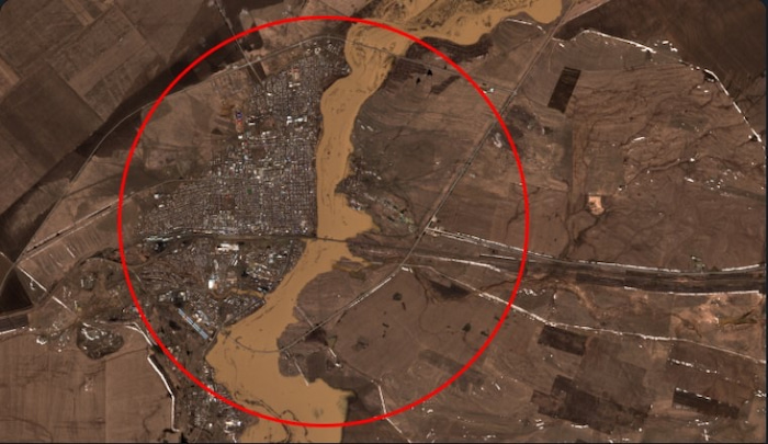
For some case studies that the EOSDA team completed, the platform was used as well. Spring floods in Northern Kazakhstan pose a significant threat to the surrounding villages and civil structures. The team of scientists used EOSDA LandViewer to retrieve high-quality images and build a custom neural network model on remote sensing and ground truth data. They managed to achieve 90% accuracy for flood prediction.
Santel-2 satellite imagery covering the area of interest in April 2019. Image: EOS Data Analytics

Custom Projects
The EOSDA team also builds custom projects catering to specific clients’ needs or showcasing the team’s abilities. Custom solutions include field boundary detection, yield prediction, crop type classification, and other types. The scientists and data engineers work on client requests to ensure the project is of the highest quality. For instance, the sugarcane harvest monitoring model was developed for a Brazilian client. The model identified and measured the harvest of 30 fields.
Another custom project aimed to classify lands in Bulgaria, Nigeria, and a part of South America. The land use classification model covered collecting the satellite and ground truth data, designing the architecture of the neural network, training, validating, and fine-tuning the model, and receiving the final results. The model identified water, forest, cropland, grasslands, etc., with high precision. The result was color-coded raster images.
Soil Organic Carbon (SOC) Modeling
One of the newest custom solutions is soil organic carbon (SOC) models. Organic carbon sequestered in the soil ensures its health and allows cleaning of the atmosphere, reducing the environmental impact of agriculture. EOSDA’s partner AgriProve, a soiltech carbon developer, is working towards reducing the carbon footprint of Australian agribusinesses. The company uses EOSDA’s help in mapping soil organic carbon for CO2 projects for its clients. AgriProve’s goal for this partnership is to use the capacity of EOSDA’s science team to create and train the model to become an invaluable tool for measuring soil carbon and ensuring sustainable practices in Australian agriculture.
EOSDA’s model uses a unique approach that combines SOC models with remote sensing technology. This helps carbon project developers, government agencies, and verification bodies to measure, estimate, and predict SOC more efficiently. By leveraging 140 different predictors, including satellite imagery, the method greatly reduces the need for expensive physical soil samples. This not only cuts costs but also improves the accuracy of SOC estimations.
The importance of SOC for sustainable development is multifaceted. Firstly, it enhances soil fertility by providing essential nutrients for plant growth, which is crucial for food security. Secondly, SOC improves soil structure, reducing erosion and increasing water infiltration and retention, vital for drought resistance and water conservation. Thirdly, high levels of SOC enhance soil biodiversity, fostering a robust ecosystem that supports plant and animal life.
Moreover, SOC is a significant factor in mitigating climate change. Soils act as a major carbon sink, sequestering carbon dioxide from the atmosphere and reducing greenhouse gas concentrations. This process helps to offset anthropogenic carbon emissions, contributing to climate stabilization.

SOC modeling is a custom solution developed based on internal proof of concept. The team focuses on this essential custom solution as it establishes EOSDA’s commitment to sustainability and environmental protection. Satellite imagery analytics is an excellent instrument for ensuring precision in many practices, including agriculture, forestry, food production, and more. Carbon sequestration in the soil is a path forward to tackle climate change and eventually save the planet.
This article was sponsored by EOSDA.
Autor: Maksym Sushchuk
With over fifteen years of experience in commercial writing and journalism, Maksym is dedicated to fostering positive change in society, ecology and the environment. His passion lies in using compelling narratives to inspire action and drive sustainable impact, aiming to create a greener, more resilient world through the art of storytelling.


