I slipped on a rock, stumbled through a bush and slithered into the water, filling my boots. Though the trail existed on my map, the real world comprised mossy boulders, dense vegetation, a tumbling river, but no hint of any path. Plus, we were under time pressure to get back to Injisuthi, repair our vehicle and drive nine hours to the next Drakensberg peak.

Iron Crown wasn't the most aesthetic summit
While South Africa’s new constitution introduced many noble changes, less welcome was the increase from four to nine provinces - since I was attempting to climb the highest peak in each one. It wasn’t a novel idea. As soon as the new provinces were demarcated in 1994, avid peak baggers headed for their highpoints - though finding them wasn’t always simple. The initial list drawn up by Cliff Murch got one wrong (Gauteng), with the current version compiled by Derek Odendaal in 2002. Then in 2011, Kobus Bresler upped the ante by completing them consecutively in nine days, and formalising a challenge with rules.
Five days earlier, my wife Fiona and I had met our teammates at Johannesburg’s O.R. Tambo Airport. Robbie Lapping was sporting a new knee and carrying a fishing rod; while Richmond MacIntyre had just discarded a sling and was held together by steel pins and cortisone. Renting a VW Kombi, we headed north on the monotonous N1, although at this stage of the trip we underappreciated boring tar roads. Crossing into Limpopo, we passed sites where Chief Makapan’s tribe had slaughtered trekboers, and vice versa.

Typical traffic on the drive to Mpumalanga
Come mid-afternoon, we were nearing the proud quartzite cliffs and impenetrable ravines of the Wolkberg Wilderness Reserve. Limpopo’s highest point, however, was just outside, in a timber plantation. A 20-minute stomp up a jeep track took us to Iron Crown (2126m). Partly forested and partly bare, it looked like a half-shaved pate, with its top a pincushion of radio masts. As we hurried back down, the sun disappeared and it was instantly dark, as if someone had flicked off the light. We spent that night in Haernertsburg, once a rough gold mining town where 90% of the population were men, but now a charming alpine retreat with antique shops, guest houses and, uncoincidentally, more women.

De Berg, as close as Mpumalanga gets to heaven
A similarly abrupt dawn found us heading southeast, past ZCC churches and chrome mines. Just outside Burgersfort, the traffic slowed to a crawl, provoking mini-bus taxis to barge past on all sides and Richmond to leap out, waving his arms and shouting instructions. Having failed to make any impact, however, and almost been crushed, he returned. Eventually, we ground past the cause of the hold-up: the prostrate body of a schoolchild, half-covered by a blanket.
More by Matthew

A late aftrenoon stroll on Nooidegedacht
For a province boasting such natural wonders as the Three Rondavels and God’s Window, I’d expected more from Mpumalanga. As it was, De Berg (2331m) involved an hour’s walk along a concrete road to a radio mast.

Sunset from the Magaliesberg
After effusively praising the velvety N4 at Middelburg, we were cursing it by Pretoria, as it sprouted tentacles curling off in different directions. Switching between Garmin, Google Maps, instinct and distant memory, we visited the same offramp three times before reaching Hekpoort just before dusk.

Fiona enjoys the view from the top of Gauteng
The North West Province’s highpoint lies within a private game reserve in the Magaliesberg. The manager, Johan, met us at the gate, pointing out the site of the battle in December 1900, when Boer marksmen picked off over 600 rooineks in the narrow gully. ‘It was a shooting gallery’, he winced apologetically, noting my accent. After a short march onto the ridge, we then stomped around in circles till we’d satisfied Richmond’s GPS that we’d trodden on the highest nodule of Nooitgedacht-West (1816m).

Hiking back from Namahadi
If the first three provincial peaks had hardly strained our sinews, Gauteng’s Toringkop (1913m) took the cake, located just a five-minute stroll from the roadside. Having entered the Suikerbosrand Nature Reserve when the gates opened at 7am, it was still cool and fresh when we drove out - startling red hartebeest and zebra as we slalomed round the 60km one-way circuit eager to press on.

Fiona descending the chain ladders after Namahadi
For while we’d bagged four provincial highpoints in less than two days, we knew we hadn’t really started. Though the northerly provinces involve a lot of driving, the metaphorical rubber only hits the road on reaching the Drakensberg. Called the Dragon Mountains by Voortrekkers and the Barrier of Spears by Zulus, this 1000km range contains three provincial highpoints - each over 3000m high and a serious outing.

Cattle jam on the road to Injisuthi
After stocking up in Harrismith, we wound up to Witsieshoek Mountain Lodge. With its expansive views, crisp air and guests looking sprightly in outdoor wear, it’s an invigorating spot – and my fine mood was only spoiled by Richmond announcing our departure time for the following day. ‘What do you do in bed after 4am?’ he asked, looking sincerely nonplussed, when I proposed a tardier start.

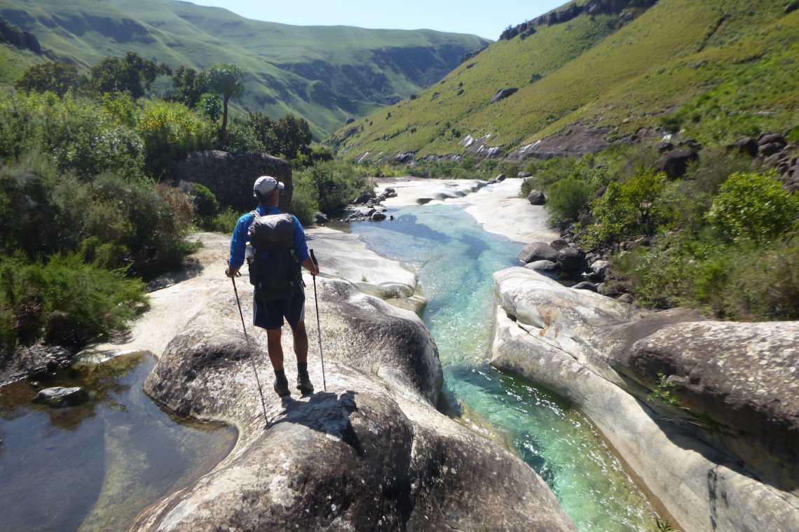
Fiona crosses a river on the hike in to Mafadi
Come the first brush of sunrise, we were scaling the metal chain ladders, originally installed back in the 1930s to help hikers onto the escarpment - though when you’re swaying 30m off the ground, this fact isn’t helpful. Having admitted he preferred fishing, Robbie was sensibly still in bed. The 32km return trip to the Free State’s Namahadi (3291m) took 8½ hours, over twice as long as the other four peaks combined - and we now felt our alpine endeavour had some credibility. Back at Witsieshoek, however, there was no time for champagne or even lunch, with Robbie having already loaded the van so we could be on our way.

Posing on the top of Judge Pass
As our Kombi crested Oliviershoek Pass, we looked down into the lush valleys framed by purple mountains of KwaZulu-Natal. This same view greeted the Voortrekkers in 1837, who thought they’d discovered the promised land, only to end up impaled at King Dingaan’s kraal. It also heralded mishap for us - if not quite so drastic - and we rumbled into Injisuthi Camp nursing a deflated front tyre.

On the Roof of South Africa
Delegating Robbie to change the wheel, the rest of us set off at dawn for Mafadi. This was the big one - a 55km return hike, with 2800m of ascent - and any doubts as to its seriousness were quickly washed away in a frigid river crossing, clinging to a wire. We made our way up onto the escarpment via Judge Pass and then followed the more stirringly named Trojan Wall. For many years overlooked in favour of Mont-aux-Sources, Mafadi is now acknowledged as South Africa’s highest peak and, while not spectacular, it does have a regal air - its summit crown studded with small rock pools like jewels.

Fiona enjoys sunrise near Mafadi
With darkness descending quickly, we bivvied a short stumble from the escarpment’s edge. On one side were the flickering nightlights of Loskop; on the other, in Lesotho, it was pitch black; while above us, the firmament pulsated with satellites, shooting stars and, less frequently, planes.

Fiona looking for Leslie's Pass
At first light we descended Leslie’s Pass, at my instigation, since it appeared in bold on my map - so I presumed it must be good. Come mid-morning, we were still blundering down the gorge, tripping over boulders, fighting with bushes, searching for a path. The consolation was finally emerging at Marble Baths, where we lounged in the murmuring pools, delaying our return to Injisuthi to ensure Robbie had changed the wheel.

Contemplating a swim at Marble Baths
The border region between the Eastern Cape and Lesotho was a region I knew very little about - and it’s still a mystery. After overnighting in Kokstad, we drove through pre-dawn fog, till the road petered out at Tabase, whose 400-strong population included 44 police officers, reflecting a local penchant for stock theft. While Robbie went to register our presence at the populous police station, Richmond, Fiona and I headed back onto the plateau.

Spicy river crossing on the way back to Injisuthi
It was another country up here, literally I think, although there was no indication where South Africa ended and Lesotho began. As we crossed a valley, a posse of horsemen came galloping towards us, wearing black cloaks and woollen balaclavas. As they fanned out in battle formation, wielding long wooden staffs, I stiffened - but they just waved and rode on. It was odd to think that they lived in the age of SnapScan, Uber and Takealot.

Descending Kwaduma as the clouds gather
After crossing several nearly identical river valleys, we finally reached a whale-backed hump marginally higher than its neighbours, which Richmond’s GPS claimed was Kwaduma (3019m). By the time we returned to Tabese, after being out 9½ hours, Robbie had caught up on the local skinner and could tell us that relations between the various cattle rustlers were currently harmonious and the police cells were empty.

House building high in the Eastern Cape
It was a long drive out of the Eastern Cape, partly due to its size, but largely its roads. This rolling green land had once been settler country, fought over by the Xhosas and British – and, reflecting its contested history, most town names had recently changed. We spent the night in what the previous month had been Maclear but was now Nqanqarhu, which we think we perfected over several bottles of wine.

Lost looking for Murch Point
The Northern Cape’s tallest peak was near the province’s borders with the Eastern and Western Capes, but proved difficult to pin down more precisely. Approaching by Kombi, a right turn at the wrong gate and a left turn at the wrong water tank got us hopelessly lost in roof high grass, with rocks dinging the undercarriage. It was like being on a bombing raid over enemy territory, listening to flak rattling the plane and wondering which one would prove the fatal hit. After an hour, we shamefacedly returned to Schanskraal Farm to clarify the directions.

On Murch Point, with Compassberg on the horizon
While Robbie crawled under the vehicle to assess the damage, the rest of us stamped up the stony flank of Murch Point (2156m). Formerly known as plain Peak 29, it was renamed in honour of Cliff Murch, who identified it as the provincial highpoint, shortly before committing suicide, aged 45. The summit was marked by a toppled trig beacon, which somehow seemed apt.

High on Compassberg
Having bagged eight provincial highpoints and with the finishing line in sight, Richmond heard a rumour that the Eastern Cape region of Matatiele (including Kwaduma) might be restored to KwaZulu-Natal, rendering Compassberg – which we could see from Murch Point - the Eastern Cape’s highest peak. We couldn’t get enough WiFi signal to ridicule this notion. More unfortunately, the owner of the adjacent farm was away shopping in George, increasing the return hike from 5 to 20km. But even if Compassberg never becomes a provincial highpoint, it deserves to be, with its thrilling profile, slender ridges and airy summit. The five-hour outing was wholly satisfactory, even if wholly superfluous, and we got down just as the wind picked up. Insured against future bureaucratic border-meddling, we reset our Satnav and headed on the R62 into the setting sun.

The view from the final summit
Though Seweweekspoortpiek (2325m) is hardly the Western Cape’s most iconic mountain, it still made a fitting finale – taking us three hours to pick our way through the maze of giant boulders and rock bands up to the summit block. So, we’d completed the nine provincial peaks (plus Compassberg) within nine days, which had a nice ring - if being somewhat outside the fastest time for the challenge, a mind-boggling 64 hours. It was only on getting home I discovered that if Matatiele was hived off from the Eastern Cape, its highest peak would become Ben Macdhui, not Compassberg. But by then I was more concerned about the rental car bill and excess liability charge.
NB. If you are planning to tackle the provincial highpoints, the following website is very helpful: www.ninepeaks.co.za
NB. If you are planning to tackle the provincial highpoints, the following website is very helpful: www.ninepeaks.co.za
Shop for a cause
Conservation Mag is an Amazon affiliate, by clicking on the links to do your shopping you support us without paying anything extra.
Shop on amazon.com | amazon.co.uk
Shop on amazon.com | amazon.co.uk