Abundant water and fewer hikers than normal mean that there’s never been a better time to hike the Fish River Canyon.

Roy White, Shaen Adey and Fiona pose on the the canyon rim - all clean and shiny
The wilderness hike through Namibia’s spectacular Fish River Canyon needs little introduction to keen hikers – it’s on everyone’s bucket list. So getting a place is usually tricky. Not so this year. The COVID pandemic has wreaked havoc with many people’s travel plans so bookings for the 2021 season have been down compared to ‘normal’ and those with flexible schedules have been able to secure last-minute bookings.

The first section of the descent is steep and aided by chains - Pic Roy White
A big bonus this year is that thanks to heavy rain early in the season, the Fish River is actually still running and the pools are clear, deep and pristine. All in all, the perfect time to Fish! A couple of friends and I went in early July and it was a truly magical experience.
There are still nearly two months before the end of the hiking season and the red tape is minimal so it’s not too late to sign up.
Tempted? Here’s everything you need to know to make it happen.

Take care on the descent - Pic Roy White
Why do the Fish River Canyon Hike?
Because the Fish River Canyon, the second largest canyon in the world (after the Grand Canyon in Arizona), is simply mind-blowing. One of Africa’s great natural wonders it’s somewhere you have to see before you die. As a result of tectonic activity and erosion, the deep, winding canyon cuts through the landscape of southern Namibia, exposing layer upon layer of rocks, some over 2 billion years old.
The reflections of these glowing red and orange cliffs at sunrise and sunset make for the most amazing memories and photos.

Much of the route through the upper part of the canyon is on sand and boulders - Pic Shaen Adey
Because it’s a true wilderness adventure. Starting from the canyon rim, the Fish River Canyon Hiking Trail takes you down to the canyon floor, from where you head south broadly following the course of the river as it snakes between the high canyon walls. One of the beauties of the trail is that there is no fixed route or campsites; rather you have the freedom to go at your own pace, taking as many days as you wish and stopping to camp at whichever beach or sandy ledge takes your fancy.
Because space, silence and solitude are good for the soul.
Because of the extraordinary star-studded skies.

There are some big boulder fields to negotiate in the first couple of days so a trekking pole is handy - Pic Shaen Adey
Other Highlights of the Fish River Canyon
The weird and wonderful geological formations, natural sculptures and stripy rocks.
The fantastic birdlife. Look out for Mountain and Familiar Chats, Capped Wheatears, Goliath Herons, Fish Eagles and Pied Kingfishers. The wildlife is more elusive but you’re likely to see the famous wild horses (we were lucky to have close encounters with two small herds), baboon and perhaps leguaan (monitor lizards). There’s also lots of scat and prints of otter, klipspringer, kudu, porcupine, cats and other nocturnal animals.

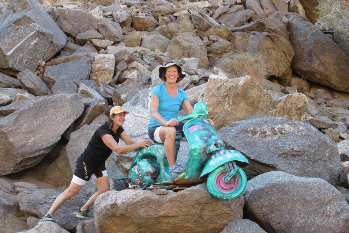
'Vidi' one of a trio of Vespas used in an ill-fated attempt to run the canyon on scooters in 1968 - Pic Roy White
The beaches and deep pools where you can strip off and skinny dip in the knowledge that there’s no one else around.
Palm Springs: they’re smelly but the natural sulphur springs are a good place to soothe your weary limbs.
Historical Sites: There is little in the way of man-made features but you’ll pass two sites of historical interest:
- Vidi, an old Vespa that was abandoned in 1968 following a madcap adventure by six intrepid members of the Cape Town Vespa Club to take three ‘canyon-tuned’ scooters down the Fish River Canyon in 1968. Read more here
- Lieutenant von Trotha’s grave. Modern-day Namibia was a German colony from 1884 until the end of World War II. Lt von Trotha was shot in the back during a skirmish with Nama tribesmen in 1905.

The reflections of the canyon walls in the river were impressive particularly at the start and end of the day - Pic Roy White
How hard is the Fish River Canyon Hike?
Make no mistake, the Fish River Canyon hiking trail is no walk in the park. But if you are reasonably fit and plan your trip carefully it is not overly strenuous. Many veteran hikers advise that it’s about the same level of difficulty as the Otter Trail.

Camp on the first night, a small sandy shelf near the river
How long will the hike take you?
We completed it comfortably in 3 nights but I’d advise spending 4 nights in the canyon to really appreciate all that it has to offer.

Take time to smell the flowers, and check out the incredible rocks - pic Shaen Adey
Here are our top tips
The trickiest part is the descent, so take it slowly and carefully. From the canyon rim, the trail drops steeply for about 460m to the river. There are some rock steps that you need to scramble down, but these are aided with chains. Once down there are deep pools in which you can swim and wash your cares away.
From there on you follow footprints in the sand or make your own way along the river for 40km or so. The soft sand and boulder hopping makes it fairly slow going. There is no obvious path but the canyon is narrow so you can’t really get lost.

You cross the river numerous times, but rarely risk getting your feet wet - Pic Roy White
Take your time for the first 2-3 days. The first half of the canyon is the most scenic and taxing. You can easily make up time on the lower section, which is much more open - more like walking in the Richtersveld.
There are various shortcuts from the 40m mark which go over low hills and necks to cut out big bends in the river. They are clearly marked on the map and with cairns and white paint on rocks. Take them. They save distance and time, traverse very different terrain to that of the canyon floor and because of the greater elevation, allow a bird’s-eye view.

Keep an eye out for wild horses in the middle section of the canyon - Pic Roy White
Safety on the hike
This is a wilderness hike and help is a long way away. So be prepared, and go carefully. Carry a first aid kit, take a good map and have a plan in case of injury.
There is very little shade in the canyon so take the usual precautions against the sun and dehydration; wear a hat, long-sleeved top and long pants, slap on the sunscreen and drink lots of water. Consider starting your hike before dawn and resting during the hottest part of the day if you hike during the hotter months of April, May and September.
There is no cellphone reception in the canyon so consider taking a satellite phone with the emergency numbers programmed in.
There are emergency exits but they all involve a very strenuous hike up to viewpoints on the canyon rim – from where it’s still a long way to the park office. If you have an emergency and you’re not carrying a sat phone try to find a group that has one and alert the park rangers who can send a vehicle to the top of the exit route. If all else fails send some of the party on to raise the alarm in Ai-Ais.
Take out travel insurance; if you need to be evacuated it will probably be an expensive helicopter rescue.

Looking back on Four-finger Rocks from the shortcut over Vasvatnek - Pic Roy White

Baboon rock. We saw and heard baboons along the way - Pic Shaen Adey
Reservations
Email

The shortcuts provide a change in scenery and perspective - Pic Shaen Adey
Getting there
It’s 680km (6.5 hours) from Cape Town to the Vioolsdrift border, then 118km (1.5 hours) from Noordoewer to Ai-Ais.

Distance markers and signage for short-cuts and emergency exits provide useful orientation - Pic Shaen Adey
Namibian Border Formalities
The Vioolsdrift/Noordoewer is open 24 hours, subject to COVID restrictions.
A negative PCR test, no more than 72 HOURS old, is currently required to enter Namibia, but check the current situation a few days before the start of your hike. (R850)
Drivers must pay a Namibian road tax (N$337) at the Noordoewer border post. Meat, fruits, beer and wine must be declared at customs.
Tip: The shop at the Shell Garage sells basic supplies, including frozen meat and droewors/biltong. There’s a Wimpy at the Engen garage a little further on.
You’ll need to have a Rapid Antigen Test (R300pp) to get back into South Africa. It’s all very quick and efficient, with results being issued after about 15 minutes.

The grave of German soldier Lt Thilo van Trotha - PIc Shaen Adey
Where to stay
Hobas has camping and chalets, but the facilities at Ai-Ais Hotspring Resort (where the trail finishes) are better. The resort has chalets and rooms and is well geared up for camping with grassy sites with braai places, tables and benches, covered kitchen areas complete with electric stoves, good, clean ablutions and a big swimming pool fed by the hot springs.
Tip: Be warned the campsite is not quiet – there are always groups of hikers getting up early and generally campers arriving late.
The restaurant at Ai-Ais has cheap beer, good value, hearty meals and a reasonable wine list. Service is good and the staff is fun and accommodating.

The canyon widens out as you make your way South - Pic Shaen Adey
Trail Details
Minimum age 12 years, no maximum age
The Fish River Canyon hiking trail is open from 1 May to 15 September. (Latest start date is 10 September)
The minimum group size is 3. If you are only two hikers, or a single check the ‘I hiked the Fish River FB page’ to see if other groups are advertising spaces.
Hikers must produce a medical certificate, signed by a doctor no more than 40 days before commencement of the hike, at the park entrance.

The going gets easier as you approach the end - PIc Roy White
Costs (NB 1N$ = R1)
Namibian road tax (payable at Noordoewer Border Post): N$337
PCR test: R850
Hiking permit: N$535
Shuttle from Ai-Ais to the trailhead: N$350pp (can be booked in advance or on arrival at Ai-Ais)
Entrance fee to the Ai-Ais Richtersveld Transfrontier Park for hikers from SADC countries: NS60pp
Conservation fee: N$40pp
Tip: Even with an early shuttle getting through the formalities – checking of medical forms, payment of fees etc - at Hobas takes time.
Camping at Hobas N$400 per site for 8 people.
Camping at Ai-Ais, N$400 per site, maximum 4 people. Chalets/rooms at Ai-Ais are currently on special - from N$550pp B&B.
Rapid antigen test to return to RSA is R300pp

The final stretch before Ai Ais Pic - Roy White
Gear to Take Along
The best advice for hikers doing the Fish River Canyon is to go light. As light as you can. Try to carry no more than 12-15kg. Choose a backpack that is lightweight and snug on your back so that you’re not thrown off balance on the boulder sections.
The weather can throw curve balls. Expect hot days and cold nights. We had sand and dust storms, rain and dew as well. A Buff is very useful for keeping out dust and sand.
Tent or bivouac bag? One of the highlights of the canyon is sleeping out under the stars. So I’d leave the tent behind and take a water-resistant bivouac bag to protect your sleeping bag. A cheap bivvy bag eg Coglan’s survival bag or space blanket-style emergency bivvy offers protection from the wind and dew but your sweat can’t evaporate so your bag is likely to be damp in the morning.
Sleeping bag: The choice of sleeping bag is a trade-off between warmth and weight. It’s likely to be cold at night so you ideally want a mid-weight, three-season bag that is rated to a minimum of 5 degrees C. A down bag offers more warmth for weight than a synthetic bag.
Sleeping bag liner: a liner (cotton, or even better, silk) adds a few degrees of warmth. It also keeps your bag free of dust and body oils, thereby extending the sleeping bag’s life.
Tip: If you go light on your sleeping bag make sure you have good base layers, beanie and a down jacket to sleep in. A Nalgene bottle https://nalgene.com/product/32oz-wide-mouth-bottle/ filled with boiling water is a great hot water bottle that will stay warm all night!
Sleeping mattress: You’re probably going to sleep on sand so don’t need a particularly thick mattress. Closed cell and lightweight inflatable mattresses both do the job so my suggestion is to take what you have.
Trekking poles Take at least one trekking pole: it’s a great stabiliser on the steep descent and boulder sections.
Hiking boots or trail running shoes? We all wore takkies but my advice is to go with what you normally hike rugged terrain in. The initial part of the descent is very steep and loose and there is a lot of boulder hopping in the first couple of days. Boots offer stability, ankle support and protection. Avoid takkies with mesh uppers – the fine sand and dust will soon fill them up.
Tip: Look after your feet. If you feel a hotspot developing stop and deal with it immediately.
Travel towel/kikoi
Water purifying system: One Drop is a good option as it’s inexpensive and tasteless.
Headlamp and spare batteries
Sun protection: Sunscreen, hat, long-sleeved shirts and long pants.

The weir just before Ai Ais - a sign that we were near the end - Pic Shaen Adey
Map

The weather can change rapidly - dust storms are not uncommon - Pic Shaen Adey

A buff® is useful for keeping out wind-blown sand and dust
Need more info

Managing your feet is critical if you are to enjoy the hike so bring plenty of pairs of socks and attend to any hotspots or blisters as soon as you feel them
Shop for a cause
Shop on amazon.com | amazon.co.uk